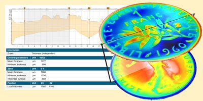
⇒ Align any pair of surfaces or profiles to create a “thickness pair” using manual or semi-automatic tools – adjust lower thickness layer to match the coordinates and orientation of the upper layer (this means thickness can be measured with any type of profiler or microscope).
⇒ Manage data from optical/confocal microscopes allowing multi-layer observation from a single scan through transparent or semi-transparent layers such as coatings.
⇒ Analyze thickness interactively between an upper layer and a lower layer
⇒ Generate global thickness parameters: mean thickness, minimum/maximum, standard deviation, skewness, kurtosis etc.
⇒ Calculate parameters at a specific point, along a line or over a zone
⇒ Define maximum and minimum thickness limits and easily identify zones that are outside tolerances (useful for applications where constancy of thickness is important: varnish, coatings, coin minting, security printing, sealing membranes etc.)
⇒ Generate stunning 3D thickness visualizations
⇒ Cross-section them to get two-profile 2D analyses of membranes with interactive measurement
Included in:
- MountainsMap® Premium
- MountainsLab® Premium
Available with:
- MountainsMap® Topography
- MountainsMap® Imaging Topography
- MountainsMap® Expert
- MountainsSEM® Expert
- MountainsSEM® Premium
- MountainsLab® Expert