Transforming a pair of standard two-dimensional scanning electron microscopy images into “topographic” images, in other words, those expressing x, y, and z (height) coordinates, can be very useful for quantifying surface features such as step height, volume, angles etc.
As a result of an ongoing research program spanning several years, Mountains® SEM software users have access to 3D reconstruction tools based on proprietary algorithms which benefit from constant improvements and updates.
Using the principle of stereophotogrammetry, this technique requires acquiring two SEM images of the same object from different angles.
However, many different factors may influence the result of reconstruction achieved in this way.
Here, we discuss why it is important that users take time to set up appropriate experimental conditions before imaging their sample and what effect this will have on the accuracy of results.
1. Consider the nature of your sample surface
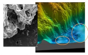
One of the major influences on good image generation is the nature of the sample surface. In particular, sample images with large uniform zones will make it difficult to correctly identify common points in each of the two images and thus perform reconstruction.

Detail of a SEM image (left) and the result of 3D reconstruction (right). The dark, uniform zones with no detail are not calculated and are “filled-in” by interpolation.
2. Make sure you get sample tilt right
Creating a 3D height model of the sample requires two images that have been tilted relative to one another.
Most recent SEMs provide options for controlling sample tilt and rotation. For the most accurate results, it is preferable to use a SEM equipped with a eucentric table.
What is eucentricity?
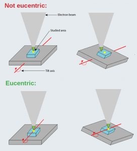
The “eucentric position” is the horizontal center of the objective lens. It is important that the sample be set to this height to avoid shift in position and focus when it is tilted. To do this, the tilt axis should:
cross through the studied area of the sample (in order to avoid the sample “escaping” from the image field) AND
be aligned or perpendicular to the scan direction.

Respecting eucentricity when obtaining an image pair will significantly improve the accuracy of reconstruction.
3. Use reconstruction software with a proven track record
Mountains® SEM software not only provides 3D surface visualization in color, it also makes it possible to carry out studies of surface metrology and in particular height measurement.
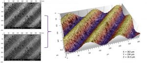
In the example below, a surface roughness reference specimen was imaged using a SEM following the guidelines in points 1 and 2.

How can I be sure of height accuracy?
Following calculation conditions defined in the ISO 4287 standard, Ra was calculated on the 3D reconstruction created using the SEM stereo pair.
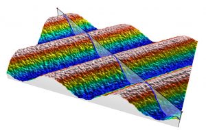
A profile was extracted from the 3D model:

Ra was calculated on this profile:

Result: the Ra of this reconstructed surface was found to correspond exactly to the Ra of the physical reference specimen.
Conclusion
Just as high quality ingredients will result in a premium food product, the quality of SEM images used for 3D reconstruction will strongly influence the end result.
Sample preparation may seem a tiresome process but, as the above example shows, output quality is dependent on getting this stage just right.
Author : Clare Jamet